

Deep Mapping
Deep Mapping
Expanding space and time to understand where it is you're from

Genealogy is not just following a family line—it is research that constructs a map. And the map is as much a guide to ourselves as it is the terrain.
In the late winter of 2023, I went to the Half-Price Books here in Louisville, Kentucky. I was looking for something, though I can’t remember what it was now. What I found, though, was a collection of three books by William Least Heat-Moon. And they were large books, too: Blue Highways, River Horse, and maybe most importantly, PrairyErth: A Deep Map.
I read them one after another over the course of that winter and spring. What I immediately discerned was how detailed Half-Moon is in his nonfiction writing. I mean, he offers every last detail, no matter how minute, about where he is, what he sees, who he meets, what they’re like, and even the foods he eats. He gives a model for how to relish life, and I noticed I began acting like this kind of writer in my own life: describing things fully and precisely. One relishes, I found, by describing thoroughly.
Blue Highways and River Horse are books about journeys, the first a cross-country drive entirely on backroads, and the second a cross-country journey entirely (or, almost entirely) on water. PrairyErth, published in 1991, is a bit different.
What Heat-Moon does in that book is to intensely explore one place: Chase County, Kansas, located in the Flint Hills. He explores it geographically, ecologically, and historically. Paul Theroux, reviewing the book in The New York Times, wrote that “It is history, travel, anthropology, geography, journalism, confession, memoir, natural history and autobiography. It is the life and times of Chase County, and incidentally everything you need to know about Kansas.”
I think to myself, how can I do this about the place my ancestors came from? What if I explored where my own ancestors are from, the Pine Creek Gorge of Pennsylvania, its creekside villages, its forests, its sandstone geology, its economic history or lumber and railroads? It’d be the task, I’d soon realize, of a lifetime.
In the summer of 2020, I drove north up Pine Creek on Pennsylvania state highway 44. I was headed into the mountains toward what I’ll call ancestral land, the site of a homestead in the Allegheny Mountains where one branch of my family, the Tombs, originates (after crossing the Atlantic and Pennsylvania, that is).
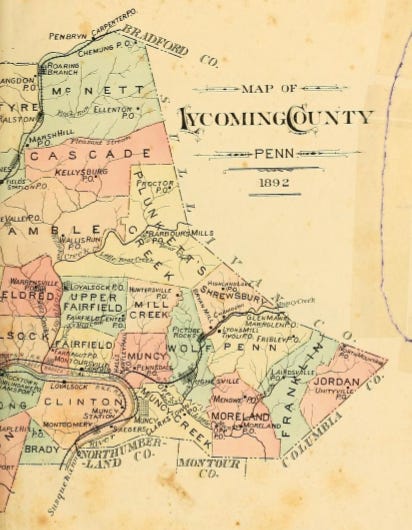
Just outside the town of Jersey Shore, where the highway crossed the creek for the first time, I saw the sign for the county line: Lycoming, where my ancestors landed in 1791 when it was still Northumberland County (it would become Lycoming on April 13, 1795). All the hills seemed to lean back from the shores, as if the gorge opened for my arrival. The further in I went, though, the closer in those hills hemmed, their layers of red sandstone glittering in the road cuts.
Five miles in, I began to see my family name where it was affixed to the landscape. First I crossed Tombs Run, where my sixth great-grandfather, Jacob Tomb (it is as often spelled Tome or Thome as it is Tomb) lived starting around 1801, after he moved downstream from Slate Run, which was my destination.
Further up, after the turnoff for Route 414, I passed the campground at Tomb Flats. I’d see these places and think, however foolishly, that in a way they must belong to me.
Finally, just over 26 miles upstream, I arrived at the village of Slate Run in Brown Township, Lycoming County. Just before Wolfe’s Market, I turned west, crossing first the Pine Creek Rail Trail, what used to be the old Conrail line (and before that, the New York Central) and is now a 65-mile long bike trail, and then the creek itself. On the far side is the Hotel Manor, where I’d made reservations.
The hotel has been there, in one form or another, for around a century, at least. But originally it belonged to the Tomb family, and a plaque placed there in 1992 by descendants marks the place as the spot where Jacob Tomb landed with his family in 1791 and where he built a gristmill by 1792. I stood there thinking, however abstractly, that I had come home.
I didn’t at that point have the term deep map as part of my vocabulary yet, but already I’d begun to explore every angle of the place I could, as if I were examining the facets of a diamond.
For some time now, I’ve been thinking about the deep map. Heat-Moon essentially coined the term, though other writers had been working with the idea, too. In the literary sense, a deep map is a documentation of a place that goes far deeper than the Rand McNally roadmaps I grew up with, deeper than mere geographical features like roads or rivers or rest stops. It attends to a place deeply—and the smaller the area, the better—by engaging not just its geographic features, whether natural or manmade, but its history, its mythology, its culture, whether current or past. To create a deep map of a place, one consults everything available: folklore, weather patterns, photographs, historical documents, old newspapers, interviews with residents, as well as its geology and ecology.
When I am standing in the dirt lot of the Hotel Manor, I start mapping. I begin to stroll the grounds: first, there is the hotel itself, with its restaurant. But I know that the original hotel burned in 2003; this structure is new. Before that, the edifice dated well back into the twentieth century, and the hotel has a long history in the Pine Creek Gorge. Prior to the 1950’s, it was known as the Manor Hunt. But I know that, as of today, I do not know its full history—when did the land, for example, pass from the Tombs to whatever new owners built that hotel? For that matter, did the Tomb descendants themselves build the hotel?
Behind the hotel is a lot for a trailhead connecting to paths extending into the Black Forest, what is today the Tiadaughton State Forest. Memory serves here; when I was in community college, up north in Corning, New York, I took a backpacking class, where the final trip was on the ridges here in this forest. I recall what it was like—the rain, the vultures, the springs atop the ridges, camping with friends down in a gully where one of us had snuck in a flask of whiskey. But from which trailhead did we start? I can’t remember.
At the edge of the Hotel Manor property is Slate Run itself—the creek, I mean. I walked to it as if it were a kind of shrine and considered the stones strewn along its bed. A fisherman tells me how the trout congregate at the mouth, where the cool water flows out of the ravine and into the warmer waters of Pine Creek. I see an osprey, and I note the cloud patterns. I see, too, on the other side of the run a big stone edifice—the original bridgehead, fashioned of slate, where the light-gauge logging railroad once ran. Its path is still there, overgrown but visible, but the bridge that carried it across Pine Creek was dismantled a century ago, and nothing remains of the rails and ties.
Across Pine Creek, if you didn’t know otherwise, you’d see only a large parking lot and a boat launch. But the deep map reveals that this is where the lumber mill stood. It has been gone over a hundred years. And beyond that, on the hillside, there once stood the Methodist Church—I’ve heard some of the older residents remembering it. Behind that is a graveyard, and in that little cemetery lie probably three generations of my ancestors (I say “probably” because it is said that the markers of the oldest graves, those of Jacob Tomb Jr. and his wife Sara, are long since lost).
So how do you build a “deep map”? I’ll detail some of the ways I do it.