
Report from Evans Landing
"...in a town that is no more a town."

I’ve been driving up and down a stretch of road along Rabbit Hash Ridge, staring into the woods, looking for a sign. There’s a cemetery in there somewhere, and you’d think it would be more easy to see. The woods, after more than a hundred years, seemed to have hidden it well.
Cell phone service is poor here, and mostly the phone says, SOS. No bars at all. There’s not much of anything up on Rabbit Hash Ridge; a few houses further on to the west, but that’s all. I’ve not seen a single vehicle on this road all morning.
The road itself is paved but narrow. Making K-turns is careful work: it’s been raining for a few days, and the ground is sopped beneath all these wet leaves at the shoulders. My Kia is only front-wheel drive, four cylinders—no use getting stuck up here. I’m far from town.
Finally, when I get a few bars of service, I have an idea: I look up the cemetery online at Find A Grave, pull up the page and—as I expected—see the GPS coordinates. I punch them into Google maps, and now I have a direction. I drive along, tracking the pin on my phone. I inch the car off the road, put on the hazards, and lock the doors.
I set off into the woods with my umbrella in one hand, phone in the other. This is private property, I know, so I move quickly, purposefully. These are not open woods, and I have to navigate the saplings, my coat sleeves and jeans snagging on greenbrier. Over a rise, I spot what must have been an old road—maybe a timber road, one of a number that weave through the woods, thin and overgrown. I follow it until it’s blocked by fallen trees.
Soon I’m standing on the map pin, but I see nothing. I’m looking around, expecting to see a purpose to the landscape—why did they choose this spot? There must be a prominence, a rise, but where? I’m looking through a misty drizzle, through the beech leaves that, if you know this country, you’d recognize in that they cling to their twigs winterlong. They won’t finally fall until spring.
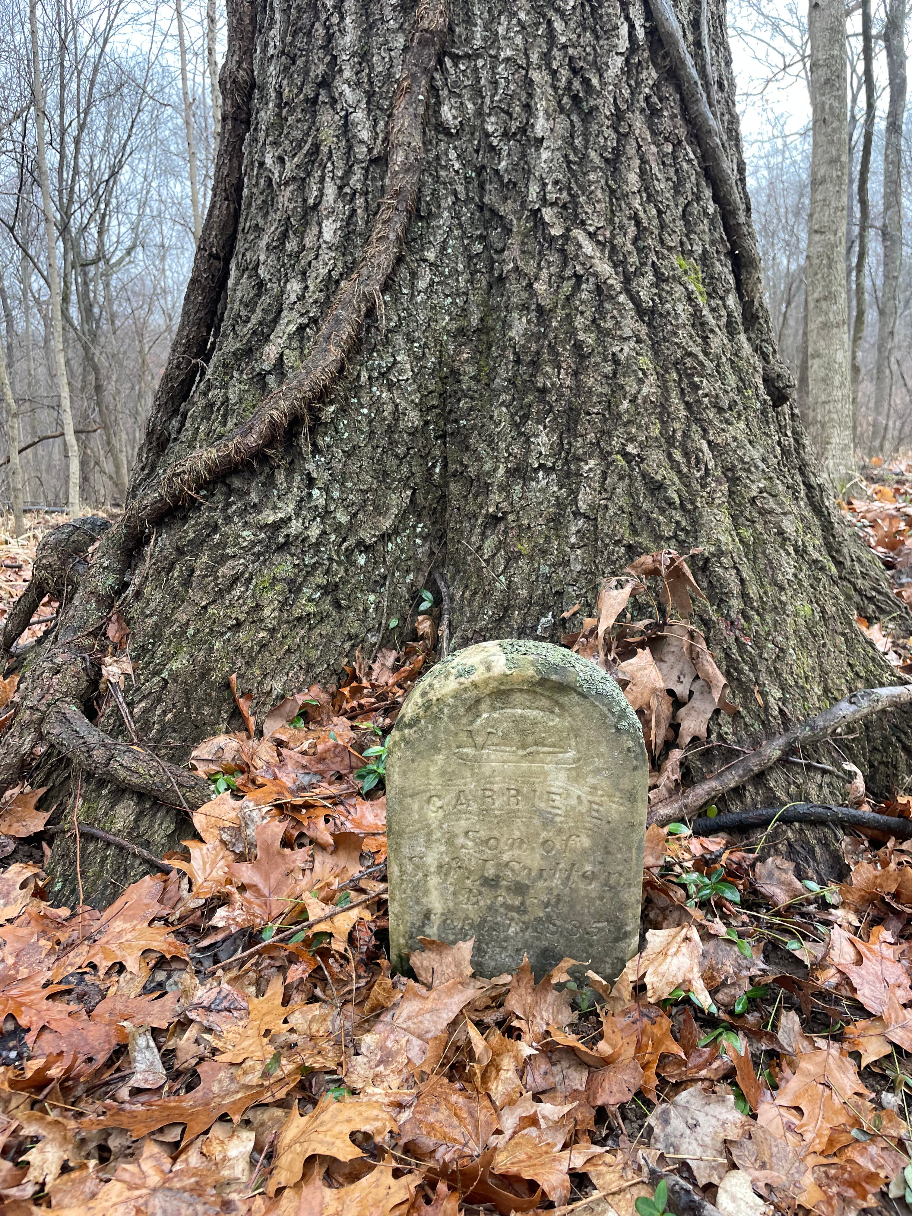
Then I see a thick black oak, far larger than any other tree here. Beneath it, the first stone. I start over and soon, like gray stumps in the fallen leaves, I begin seeing the others. At last I see the signpost, tall as me and shaped like a cross, bearing only the word cemetery. The whole plot is overgrown, clearly uncared for, unmaintained. These people, I realize, are forgotten.
I walk among the gravestones, trying to descry the names. There’s only nine standing stones and nearly half are children. Most died only days old. Abe, Sophie, Garrie, Clover: all buried between 1885 and 1893. I visit each stone, out of respect.
I head back to the car, following one of the old paths. It’s mostly used by deer, I’d guess. There may be bobcats back there, but most of the big animals are gone. Most of the big trees, for that matter, are gone, as are many of the homes that were once scattered through these hills and on the river bottoms below me.
These hills, in southern Indiana, have no name. Many of the creeks, too, more like brooks, really, falling off the ridge along the road shoulders, are likewise nameless. All through these hills you’ll find abandoned houses. It’s hard to tell how old they are. The barns, falling down on the bottomlands of the Ohio River, must be at least a century old, maybe more. The people that lived down on the river were mostly farmers.
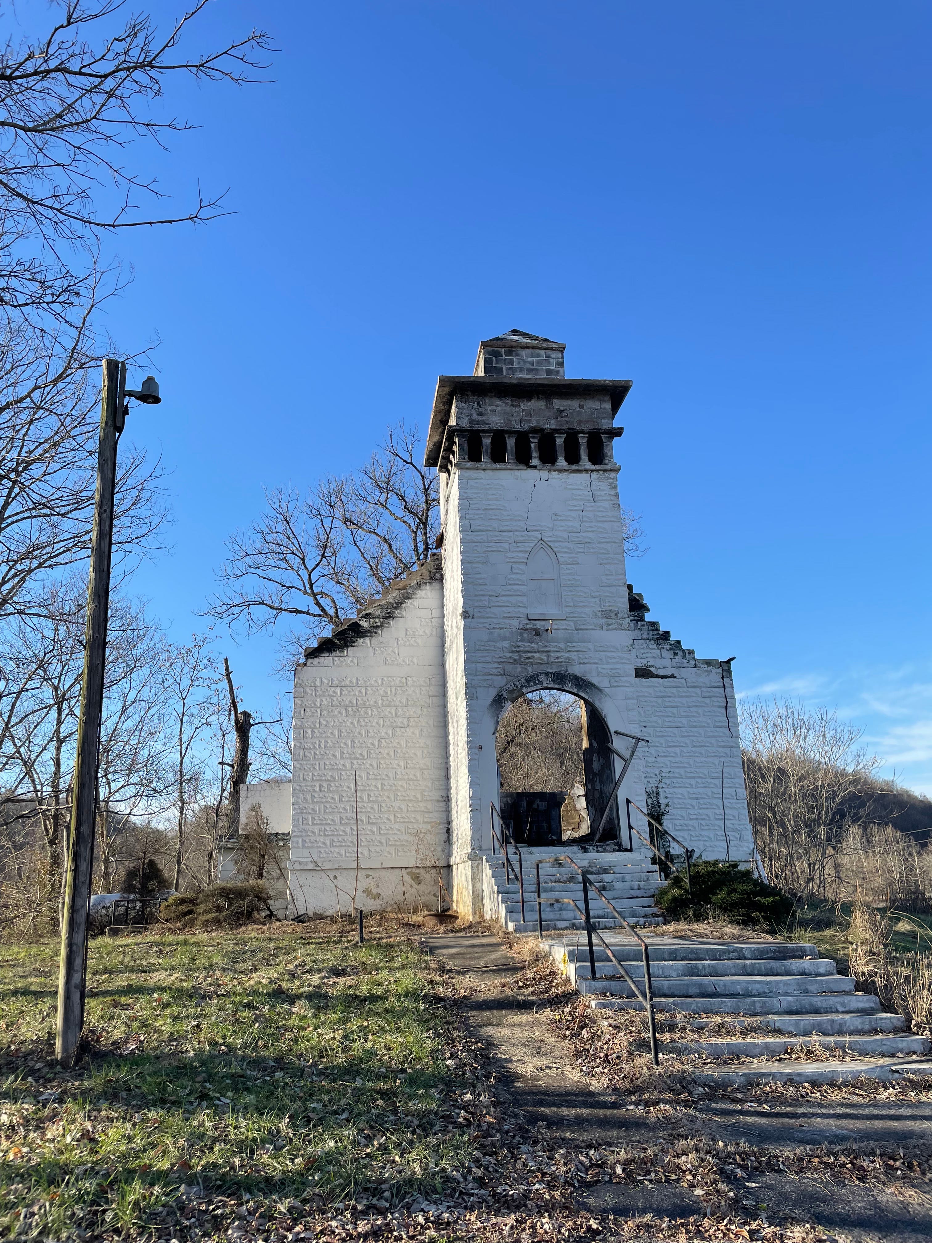
Their towns, too, are gone. Some of the names linger—Evans Landing, Rosewood—and perhaps a church, like the Presbyterian one at the bottom of Rabbit Hash Ridge. To the east, Moore’s Chapel, built in 1922 on the bank of Four Mile Creek, recently burned. Only the white stones remain—the windows, roof, and floor are all destroyed, the bell gone—only the yoke remains, tangled in rope.
I follow Rabbit Hash Ridge Road north to the headwaters of Little Mosquito Creek and the Rosewood Road, continuing north, crossing the main branch of Mosquito Creek—you can see the exposed stone there; the bedrocks here are dolomite, sandstone, shale—and onto Highway 11 and through a few small towns—Elizabeth, New Middletown—and on to Corydon, the old state capitol, where I’m headed for the Harrison County Library and the genealogy center there.
Located in an original Carnegie Library, the Frederick Porter Griffin Center is a large room with documents, maps, and computers. Kathy Fisher, the department head, brings me manila folders of newspaper clippings from the early twentieth century and a stack of USGS maps for southern Indiana.
I am looking for information specifically on Evans Landing, where today there are a few homes—one is for sale on Old Highway 111, four bedrooms and a bath for $325,000—and the church with its cemetery of over three hundred graves. I begin with the documents.
The first people to camp there, at least according to one Mrs. Abel Colvin, interviewed in 1962, were the Shawnee, Piankeshaw, Miami, and Potawatomi peoples. These were hunting parties; it would would have been a country, I’d think, rich with fish and mussels from the river, with woods full of game, deer, wild turkey.
The earliest white settlers came to the area, what would be Taylor Township, around 1807, and a ferry was established at Evans Landing about three years later. Farming along these riverbanks was clearly the main industry. “I have seen the banks full of wheat, onions, apples, in barrels then straw, hoops, and livestock,” in addition to corn, tobacco, wheat, soybeans, cattle, and hogs, writes Mrs. Colvin. “The river overflows and makes the land better,” she says.
There were no roads in and out of this country. In the nineteenth century, mail came from West Point, Kentucky across the Ohio by rowboat. In 1918, when the river froze solid, the mail carriers walked across. A post office was established at Evans Landing in 1894 (though other dates say as early as 1870). Nine schoolhouses were scattered through the hills across the township.
People here seemed to have prospered. But in 1937, the Great Flood washed most of the town away. It never recovered. Rosewood, too, is gone. Those who were left were overjoyed when electricity came in 1939.
What’s left are a few houses along the highway, farms here and there—corn, mostly it seems, though I’ve seen a few black cattle and hogs—and the little cemeteries, many vanishing back into the woods. I’ve seen the foundations of springhouses, rusted silos, crumbled barns and houses.
I asked the women working in the library, simply, what happened?
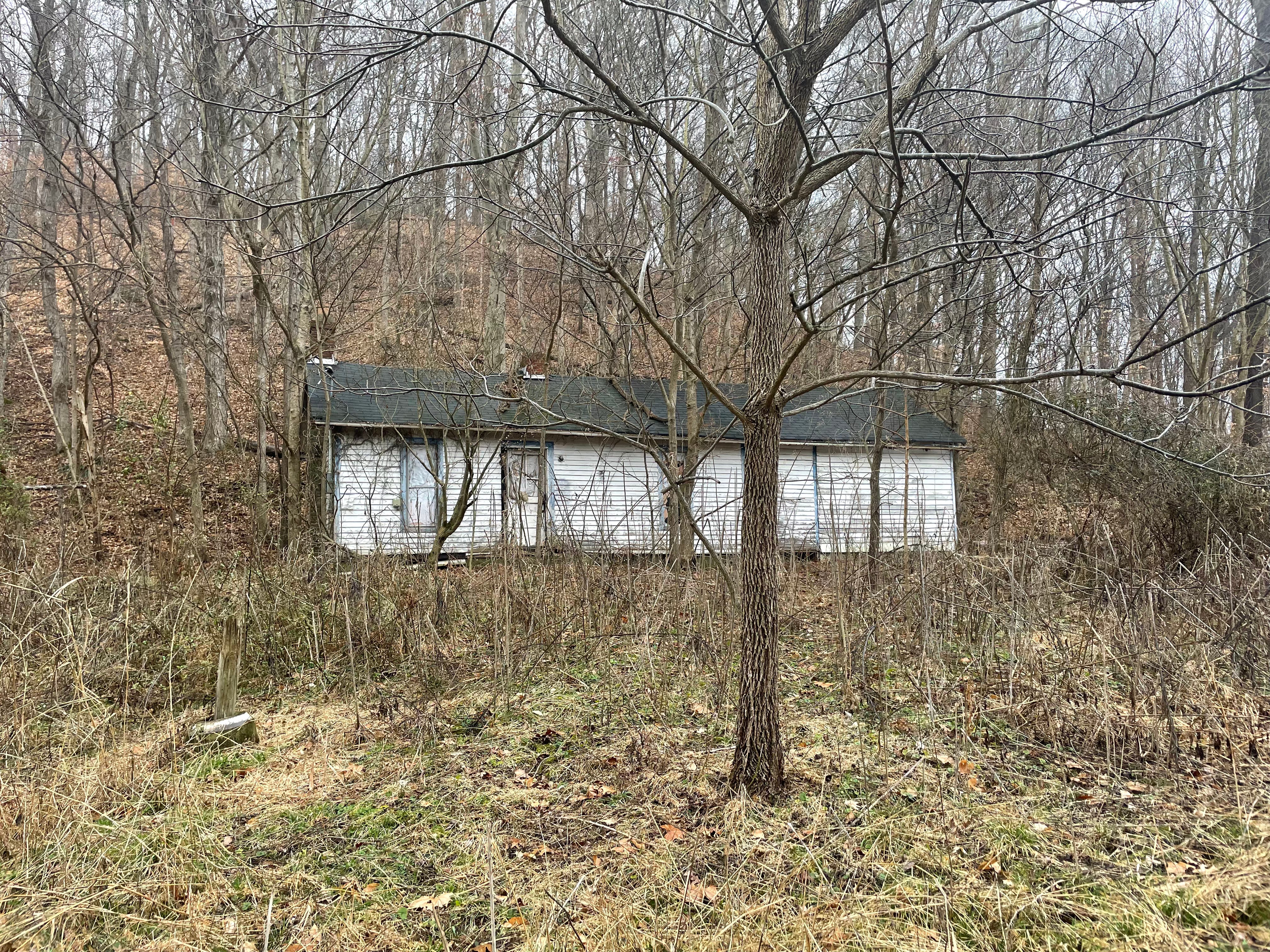
Close to where the Rabbit Hash Ridge Road opens up onto the floodplains of the Ohio, there’s an empty house. It’s hard to say how old it is, but it looks to have been a log cabin originally, a dogtrot house, as they were known in the South, where two rooms were divided by a breezeway—you can see where that opening was patched by a rough wall. Two chimneys, broken windows stuffed with sheets like gauze, and a door left slightly ajar: it’s a ghost huddled against the hillside.
One day I was photographing down around the church. An older couple came into the cemetery in a little red pickup, leaving flowers, it looked like. I kept my distance, of course. I was out back of the church, in the shade of a black walnut, the ground black with rotted husks. A few old outhouses back there, long unused, and a shed peeling its veneer in strips, were getting swallowed by the encroaching woods.
I was standing along the gravel road when the truck pulled up. The old man—his cap said he served in Vietnam—asked me if I was photographing for the paper. Just for myself, I said. It was his church, and he was, if I remember correctly, on the board. His wife asked if I had people buried there. No, I told her, though I do up north at French Lick, and east of that, in Scott County. Two of my ancestors from up that way fought in the Civil War, I told them: the battles at Perryville over in Kentucky and at Stones River in Tennessee.
I asked them about the highway, which the map on my phone said was closed due to flooding—we’d had a lot of rain and snow lately—but they said no, they were headed that way to visit more graves. In a moment, they were gone down the river road, past the house for sale, past all those ruins.
By January, I was fashioning all this information into a preface for my manuscript, the Tombs of Slate Run. I struggled with and fussed over it for something like a month. As of this week, I’d completed some nine pages to add to the previous prologue, giving me enough pages that I might use it now to apply for a grant. I hadn’t felt this accomplished in a time.
There’s more to say about this place, Evans Landing—for one, there are two Civil War survivors buried up in those hills, in two the the little cemeteries. It’s amazing to think how much history eddies on two small pins on the map, the existence of which are hardly known.