
The Map and the Territory
The old names

Descriptions of the Pine Creek Gorge from the time my ancestors lived there, at the close of the eighteenth century—especially geographic descriptions—can be hard to find. I’d been reading Philip Tome’s Pioneer Life, and I was poring over Google maps, trying to make sense of Pine Creek as he described it.
If you’re reading me for the first time, it’s helpful to know that Philip Tome is the son of my sixth great-grandfather, Jacob Tome (often spelled Tomb), and so is a distant relative. I’d turned to Tome in order to understand more about that family; Philip’s half-brother, Jacob Jr., is my fifth great-grandfather, and the three of them would frequently hunt together.
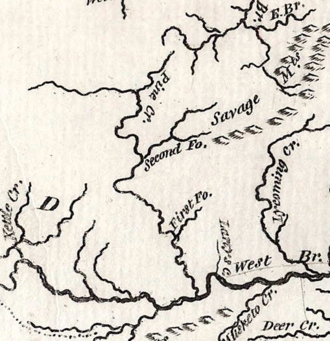
Tome will often describe traveling and hunting expeditions in terms of how many miles they went, and his mileage is almost always wildly off. He uses mileage to describe movement up and down Pine Creek, and his detailing of the creek with its “first” and “second” forks can make it difficult to ascertain as to where these forks actually were.
I’d been reading about one of the elk hunts he did with his father, beginning on New Year’s Day, 1800. It turned out to be a bit easier than I thought to find a map of the territory at the time, and, with a little patience, I found the map pictured above.
What struck me right away was that the details on the map actually matched Philip’s description, especially as to what Philip calls the first and second forks of Pine Creek. The “First Fo.” as I’d suspected is Little Pine Creek, and the “Second Fo.” (which runs up into the fantastically named “Savage Mts.”) is today’s Babb Creek, which empties into Pine Creek at the little village of Blackwell.
Then I noticed more: emptying into the West Branch of the Susquehanna is “Larry’s Creek,” which retains the name today. In Pioneer Life, Tome writes that his father had originally settled for a time in 1786 “at a place called Farris creek in what was then Northumberland county…” Historians have suggested that “Farris” was a misspelling or mishearing of “Larry’s.” And that could well be the case.
The whole of the 1800 map looks like this:

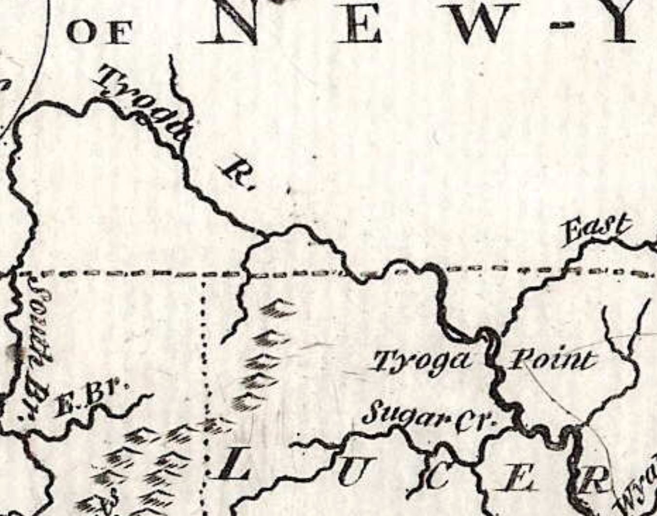
There were even more surprises. One was the name of the river I grew up on, the Chemung River, here called the “Tyoga R.” or, in today’s spelling, the Tioga. It comes from the Iroquois word teyo:ke, meaning junction, fork, or “at the forks.” Indeed, the major fork of importance is the fork of what is today the Chemung and the Susquehanna, what was for the Seneca an important place.
On this map the whole of the Chemung—which begins at the meeting of two rivers, the Tioga and the Cohocton—is named the Tyoga, which today does, as the map suggests, extend south into Pennsylvania (the “South Br.”), with another branch, the “West Br.” representing today the Cowanesque River (where, in fact, I have more relatives buried in the dwindling village of Knoxville).
This was the name used in maps and writings until 1836, when the New York legislature divided Chemung County from Tioga, and the river took on the name that, supposedly, the Delaware Indians had given it (Chemung has been said to mean something like “big horn,” referring to a mammoth tusk that was found in a bank of the river by the Seneca).
But there’s something in that name, Tioga, that seems magical, musical. And it calls attention, of course, to the original people here, most typically the Seneca, one of the five, and later six, nations of the Haudenosaunee, the “People of the Longhouse.” This was their country. These were their names.
Even Pine Creek carries, in the histories at least, the original name Tiadaughton, now the name of the state forest in that region of Pennsylvania. This, too, is an Iroquois name. All of this is the watershed of the Susquehanna River, which empties into Chesapeake Bay.
It’s interesting that there are virtually no towns or villages detailed on this 1800 map. On Pine Creek, the villages of Slate Run, Cammal, and Cedar Run are all missing. Downriver, there are the notable settlements like Harrisburg, but even Williamsport is missing. Elmira, the town I grew up in, was founded as Newtown in 1792 (it would be named Elmira in 1808), but here that part of the map is blank.
Zooming into the Google map in the vicinity of Blackwell, the detail blossoms. Just below the village, Big Run empties into Pine Creek. Following that stream up the Big Run Road, each hollow is named: Brill Hollow, Number Hollow, Campbell Hollow (this one named for one of the earliest settler families). Up Babb Creek, we find Windfall Hollow, Ayers Hollow, Stony Fork, Brown Point, Brooks Hill Hollow, McCluskey Hollow, Harrison Run, Slide Hollow, Hickory Ridge.
I imagine my ancestors, in 1800, hunting these hollows, following these creeks, topping these ridges. There is something about place names that strikes us. I am reminded of lines from one of Wendell Berry’s poems, “The Record,” which I first read decades ago:
I know the panic of that wish to save
the vital knowledge of the old times, handed down,
for it is rising off the earth, fraying away
in the wind and the coming day.
As the machines come and the people go
the old names rise, chattering, and depart.